Navigieren auf STI Bus AG
Sprunglinks
Suchbox
Hauptnavigation

Pfingstegg via marble quarry to Glacier canyon


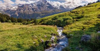
A nature trail leads from Pfingstegg over rocks and through the forest to the marble quarry. On the way there, the landscape is characterised by rock formations shaped by snow and water. The hiking trail runs mainly through the forest and leads down to the marble quarry, where the precious stone was mined until 1903. Finally, a bridge leads over the glacier canyon at a dizzying height. After another short ascent, the trail zigzags down through the forest to the glacier canyon.
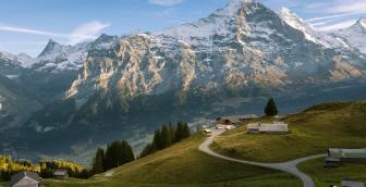
Pfingstegg: The starting point of this easy hike invites you to linger. In addition to a restaurant with a magnificent view of the village of Grindelwald and the surrounding mountain peaks, the excursion destination offers outdoor experiences such as a summer toboggan run or a «Fly Line». But the glacier canyon is calling. The mountain hiking trail leads past the «Schweizer Familie» fireplace and into the forest. Right from the start it is clear, that this mountain hiking trail requires good footwear and sure-footedness. The route leads out of the forest over rocky ground. Snow and water have abraded the rock masses lying there finely and in waves. The subsequent short ascent is easy thanks to the staircase-like section. Then you reach Wyssefluh.
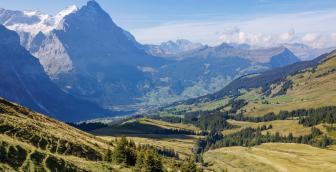
From there, the route descends also staircase-like along the mountain hiking trail. The path in the forest is steep in parts, so hiking poles are very useful in these places. The next waypoint is the marble quarry at 1,120 metres above sea level. In addition to a restaurant, there are also outdoor amusements such as «Canyon Jump» and «Glacier Bungee». A few metres away from the hiking trail, you will also find information about the mining of the precious stone until 1903. Another section leads through the forest before you cross the glacier canyon bridge. The view into the deep canyon is impressive and invites you to linger on the small plateau that follows. Before the path leads downhill again, there is a short climb in the moss-covered forest. The route then zigzags down in wide bends to the destination. If you wish, you can shorten the wait for the bus with a visit to the glacier canyon. Or you can enjoy a little refreshment in the restaurant.
You can find more information about the glacier canyon on its website.
Overview plan summer

Prices
Local bus ticket Grindelwald
| Single journey | Price |
|---|---|
| Single journey, adult | CHF 3.00 |
| Single journey, with Half Fare Travelcard / Children 6 – 16 years | CHF 2.20 |
The local bus ticket is valid for a single journey in the local bus network. Valid for 45 minutes from issue.
| 1 Day Pass | Price |
|---|---|
| Adult | CHF 8.00 |
| Adult with Half Fare Travelcard / Children 6 – 16 years | CHF 5.00 |
Prices subject to change
GA, Junior Travelcard and Children's Co-Travelcard are valid
Timetable
You can find the timetable for line 126 in the timetables.
Search for a connection
Directly plan your journey at the start of the offer.
Arrival journey
 to Pfingsteggbahn from Gletscherschlucht
Further information
Find more information about the journey here (hiking map, altitude profile and/or a video).
Erklärungstext zu Höhenprofil
The hike starts at Pfingstegg at 1,387 metres above sea level. There is a refreshment stop here. The path leads down to the marble quarry and on to the destination of the hike, the glacier canyon at 1,030 metres above sea level. In total you walk a distance of 2.7 kilometres. You can expect a walking time of one hour and 10 minutes. Hiking in the opposite direction via the marble quarry to Pfingstegg at 1,387 metres above sea level takes one hour and 40 minutes. The hike cannot be interrupted en route, as there are no stops along the way.
Plan and organise your journey
Have the entire hike compiled as a PDF or download the GPS file.
Our tip: Open the GPS file conveniently on the go with the hiking planner app from the Bernese hiking trails.
Share the journey with your friends.