Navigieren auf STI Bus AG
Sprunglinks
Suchbox
Hauptnavigation

Bussalp via Abbachfall to Weidli


The starting point for this short and easy hike is Bussalp. The marvellous view of Eiger, Mönch and Jungfrau is simply breath-taking. The route initially leads down a small, steep path towards Holzmattenläger. From there, you continue along meadow and forest paths towards In Matten. There the route leads along a dirt track. On this section to Abbachfall, you can enjoy a wonderful view of the mountain peaks on the opposite side. Shortly before the end of the hike, at the Weidli bus stop, you can admire the thundering Abbachfall from close up.
Once you arrive at Bussalp via the 126 busline, it's worth taking a detour to the viewpoint, which is only 15 minutes away. The view of the Bernese Alps with their imposing peaks is breath-taking. Back at the actual starting point, the route leads down a narrow meadow path towards Holzmattenläger. The first special nature experience awaits you on this section. Marmots can be found halfway up the trail. Their warning whistles can often be heard, but it is especially nice to encounter these shy animals directly. Curious, they poke their heads out of their burrows and look at the hikers.
The hiking trail finally leads over the rushing Bussalpbach stream via a metal footbridge. Before Holzmattenläger, the signpost points to the right, down through the shady forest and across lush green meadows. The path finally joins a dirt track, the access road to the In Matten area. This is an easy and comfortable route to the next waypoint. The view sweeps over the marvellous mountain world of Grindelwald again and again in the extensive curves to the Abbachfall. The waterfall can be heard and seen from afar. It unfolds its full splendour shortly before the end of the hike. At a bend in a small wooded area, the falling water is only a few metres from the road. After the longer section in the sun, the cool, moist air at Abbachfall is very pleasing. The last section on the road to the Weidli bus stop is just a few minutes' walk. Two benches invite you to linger there until the bus to Grindelwald arrives.
Overview plan summer

Bussalp mountain restaurant
The cosy mountain restaurant on Bussalp invites you to linger and relax. Treat yourself with culinary delights from the kitchen and enjoy the unique view of Eiger, Mönch and Jungfrau.
Prices
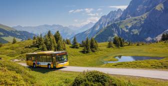
Line 126, Grindelwald – Bussalp (mountain line) /summer
Timetable
You can find the timetable for line 126 in the timetables.
Search for a connection
Directly plan your journey at the start of the offer.
Arrival journey
 to Bussalp from Weidli
Further information
Find more information about the journey here (hiking map, altitude profile and/or a video).

Erklärungstext zu Höhenprofil
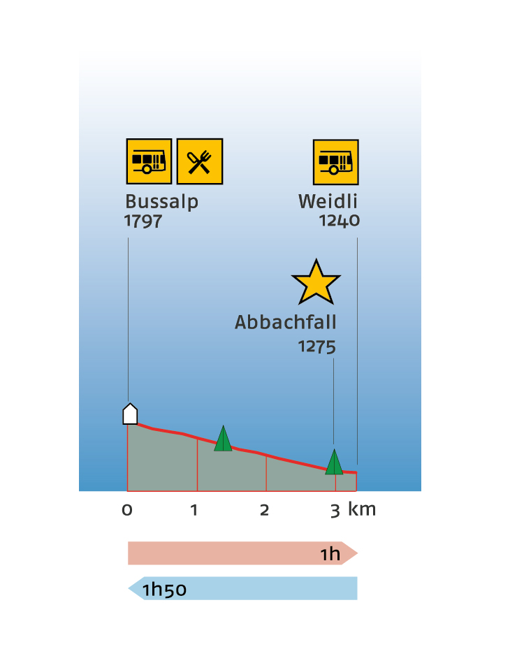
The hike starts on Bussalp at 1,797 metres above sea level. Here you will find a place to stop for refreshments. This is the highest point of the hike. The path leads down to the highlight of the hike, the Abbachfall waterfall at 1,275 metres above sea level. 3 kilometres of the in total 3.3-kilometre route have already been walked at this point. You can expect a walking time of about one hour. The route continues down to the end of the hike: Weidli at 1,240 metres above sea level. The entire hike is expected to take one hours. The hike cannot be interrupted en route, as there are no stops along the entire route. Hiking in the opposite direction takes about 10 minutes to Abbachfall at 1,275 metres above sea level. Plan a total of 1 hour and 50 minutes for the entire hike to Bussalp, the highest point of the hike, at 1,797 metres above sea level.
Plan and organise your journey
Have the entire hike compiled as a PDF or download the GPS file.
Our tip: Open the GPS file conveniently on the go with the hiking planner app from the Bernese hiking trails.
Share the journey with your friends.